
Sea Level Rise
The threat of sea-level rise has permeated the globe and cities are trying to redress the balance. Adapting to sea-level rise requires constant evaluation of protective systems and will remain a work in progress for centuries to come.
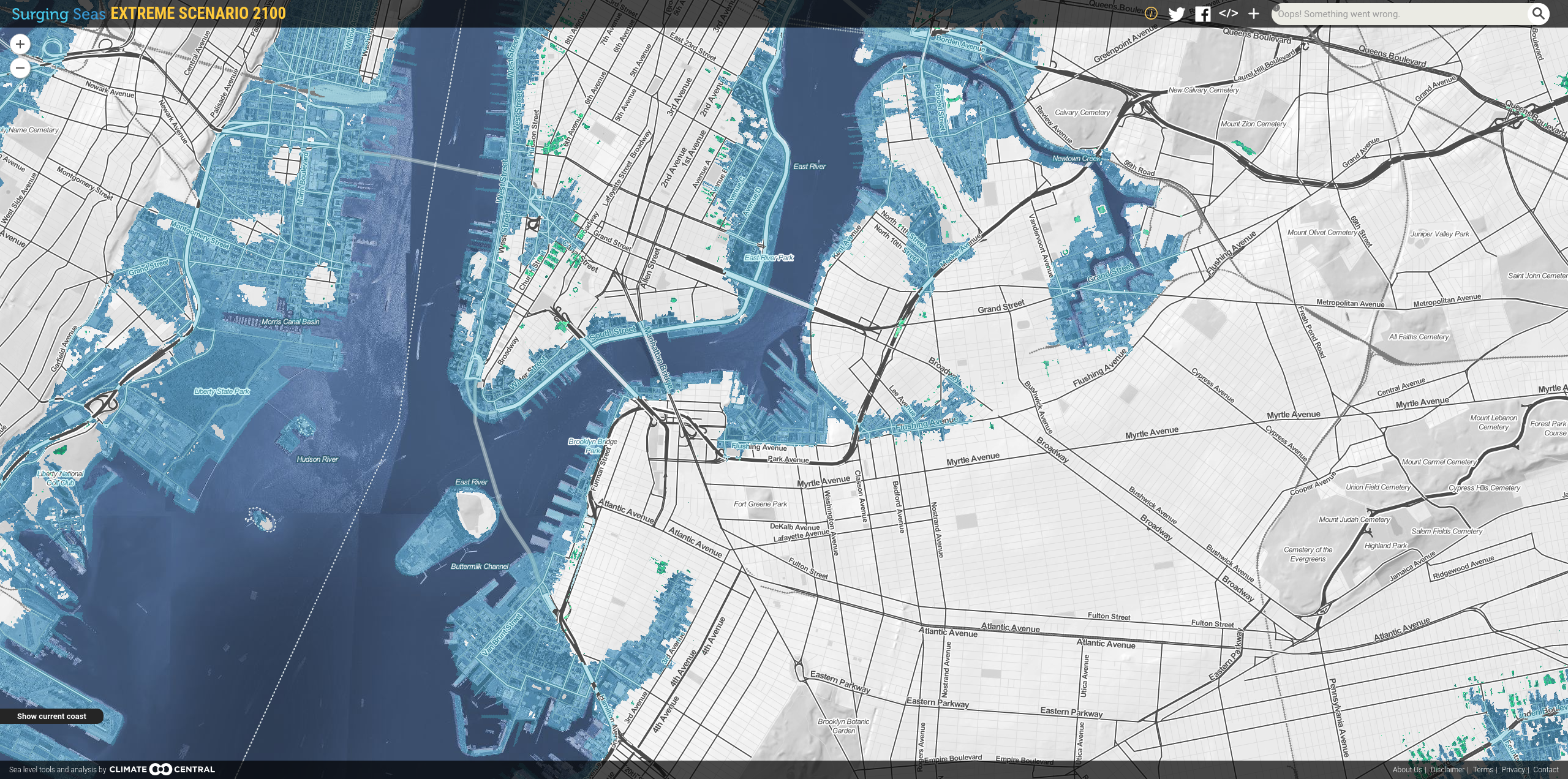
In terms of Earth’s history, global sea-level rise is no new phenomenon but the increasing rate at which it rises is directly related to human activities. As we continue to emit greenhouse gases into the atmosphere, oceans have absorbed more than 90% of the heat from these gases, and its impacts are hard to ignore. 2018 set a record for ocean heating and the global mean sea level is projected to rise 2 meters by 2100. There are several interactive flooding maps available online that offers accurate elevation data, allowing users to explore coastal flood risk and sea-level projections geographically. These maps highlight especially low-lying coastal cities around the world, from Boston and Manila to Shanghai and Singapore.
In a bid to turn the tide on sea-level rise, a growing number of cities are stepping up to this climatic challenge by trying to lower its urban interference with the natural water cycle. As such, nature-based solutions such as green roofs, rain gardens, permeable pavements, and wetlands are favored. Of the myriad of mitigation strategies, here are 3 main approaches that most are undertaking,
Hard engineering approaches e.g. Sea walls, surge barriers, water breakers, water pumps, and overflow chambers.
Environmental approach e.g. Mangrove and wetland rehabilitation.
People-centered approach e.g. Floating buildings, urban design regulations, resilience building, and retreating from the shoreline.
On its own, each measure has their own set of pros and cons. While the hard engineering approach significantly reduces the risk of loss as soon as the project is completed, its reliance on concrete walls and pump systems is limited. And while mangrove and wetland rehabilitation reinforce existing ecology’s protective capabilities at a lower cost, the environmental approach is vulnerable to the effects of climate change, where certain species may not be able to adapt to the already climate-challenged ecosystem. Hence, the projects and case studies that are most assuring are those of multi-pronged measures.
To combat flooding, Rotterdam has invested in a large hard engineering feat by building the Maeslant barrier, which closes when water surges past a 3 meters height. Since 90% of the city lies below sea level, the Dutch have learned to live with the river, by giving room to water in their infrastructures. Open plazas and parking garages have been designed to hold water and redirect it back to the river. Permeable pavements and softscape are preferred to increase water absorption capacity.
China’s Sponge city campaign was initiated in 2015 to primarily restore local hydrology via a systems-based stormwater management approach. The strategy requires that 80% of urban land has the capability of absorbing or reusing 70% of all stormwater captured. Like Rotterdam, Shanghai has installed massive mechanical gates to moderate overflowing rivers and constructed 520 kilometers of protective seawalls.
Singapore is building upon its land reclamation schemes and plans to implement wall and stone embankments across 70-80% of its coastline. The remaining 20-30% are reserved for softer approaches like beaches and mangroves. Within the city, the local water-sensitive urban design programme “ABC Waters” works to improve drainage while the minimum height for land reclamation projects was raised to 4-5m above mean sea level.
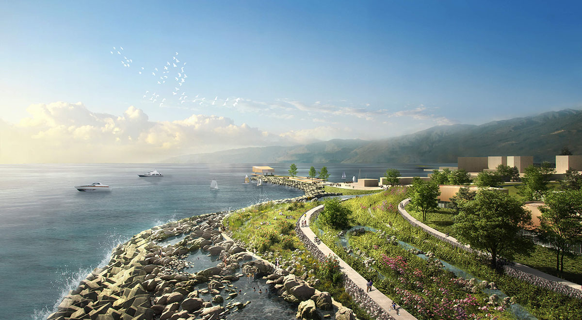
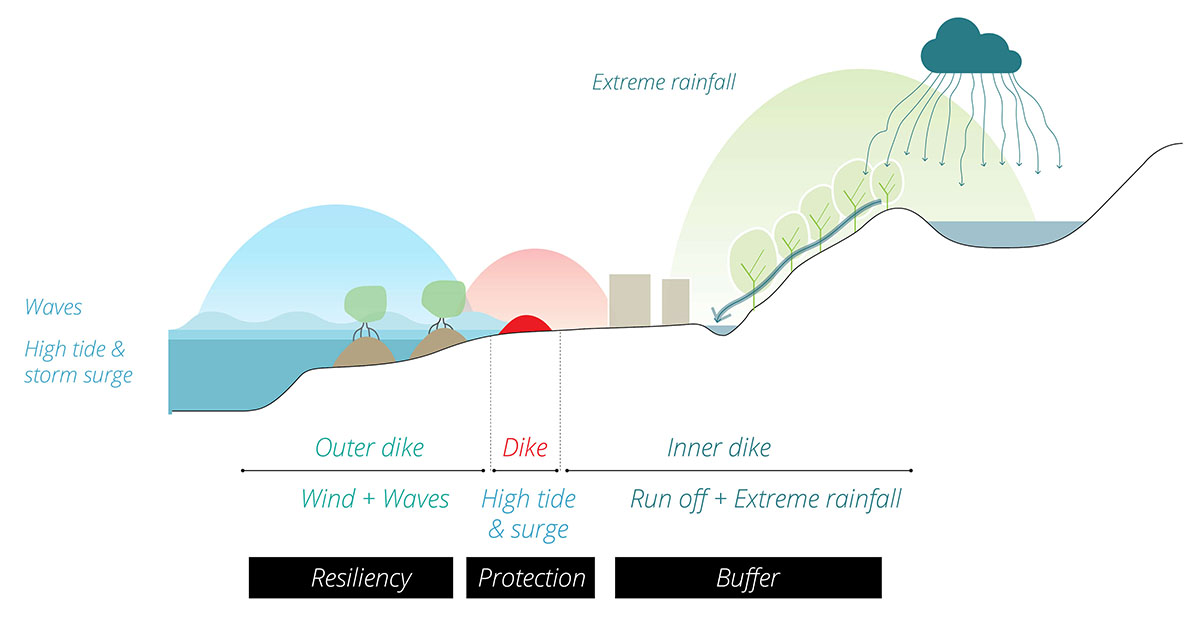
In one instance, KCAP and FELIXX have developed a “Triple dike strategy” for the redevelopment of the 130 kilometers coastline of Dapeng (a peninsula between Hong Kong and Shen Zhen). This multi-faceted dike system promotes an integrated approach towards the climate-adaptive reorganisation of the shoreline. According to World Architecture, the first outermost dike zone aims to reduce erosion and enhance sedimentation and the second middle dike acts as an elevated embankment that prevents storm surge from being pushed up the shore. The third and innermost dike is a hybrid structure that manages rainwater observing the Sponge city principle.
As sea level rises incrementally, cities are trying to redress the balance. Dealing with the water edge and adapting to sea-level rise requires constant evaluation of protective systems and will remain a work in progress for centuries to come. The need for nature-based urban design and landscape architecture will grow in parallel with the sea-level rise to offset the concrete jungle’s limited absorption capabilities.
About the Author
 | Crystal Cheng graduated from the Technological and Higher Education Institute of Hong Kong with a Bachelors's degree in Landscape Architecture. During her stay in Hong Kong, she was awarded the HKSAR Government Outstanding Performance Scholarship in 2019 and was actively involved in the Hong Kong Institute of Landscape Architects, where she served as Vice-Chair of its Young Landscape Architects' Group and represented the institute on multiple occasions. She is currently one of the pioneer leaders of IFLAAPR's Young Landscape Architects' Alliance and will be undertaking her Masters in Urban Design with the National University of Singapore this year. |